Introduction
The Penrhyn Basin is a subsea marine region located South of -9° Latitude, in the Southern Pacific Ocean, at a depth of around 5,200m. It covers an area of around 2,000,000km², between the islands of Penrhyn and Aitutaki in the Cook Islands. The basin is primarily located in the Cook Islands Exclusive Economic Zone (EEZ), but also parts of the Kirabati and French Polynesian EEZs, along with adjacent international waters.
The Penrhyn Basin is of great interest because it contains a large density of high grade polymetallic nodules. It is typically regarded as being the second most promising source of polymetallic nodules; after the Clarion Clipperton Zone, but ahead of the Central Indian Ocean Basin and Peru Basin.
Subsea Environment
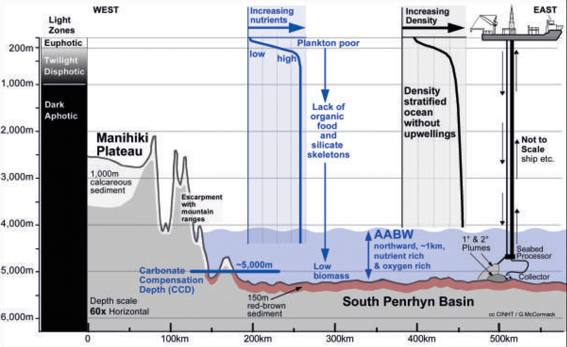
The Cook Islands seabed consists of a comparitively shallow Manihiki Plateau in the northwest around the Island of Suwarrow, at a depth of around 2500m, and the very deep South Penrhyn Basin from the Island of Penrhyn southward to to the Island of Aitutaki, at a depth of around 5200m. Polymetallic nodules are mostly found on the South Penrhyn Basin seabed.
The basin is impacted by the Antarctic Bottom Water (AABW), which is a body of cold water (around 1°C) flowing northward from Antarctica, forming a current about 1000m high on the seabed. The temperature, and consequent density, of this water body mean that it flows around the Manihiki Plateau rather than over it. The AABW brings oxygen-rich water, which helps the growth of bacteria and increases productivity.
Nodule Formation
The seabed sediment of the Penrhyn Basin consists predominantly of red-brown clays, on which the polymetallic nodules rest. The clay sediment of the Penrhyn Basin is thicker than the soup-ish mud of the Clarion-Clipperton Zone, potentially reducing the sediment plume caused by mining.
The nodules themselves are blackish spheres with a smooth surface, typically 2-8cm diameter. They lie on the surface of the red sediment where they grow by the continuous addition of minerals from seawater, having formed around an inert nucleus, such as a shark tooth or rock fragment.
Polymetallic nodules form throughout the global ocean, predominantly on the surface of sediment-covered abyssal plans at depths of 3500-6500m. Nodules mainly form in areas of low-mid productivity (that is, the amount of plankton and animals to form corpses and faeces to sink to the seabed), low sedimentation rates, below the Carbonate Compensation Depth (CCD) and in areas where intert nucleii (e.g. a shark tooth or rock fragment) are present.

Nutrient levels in the Penrhyn Basin are very low. Despite significant amounts of sunlight, there are virtually zero surface nutrients, and the area is effectively a "biological desert". This means that there is little plant plankton, and consequently few animals, and thus low quantities of corpses and faeces to provide food for seafloor animals. Deep sea abyssal plains are already relatively devoid of animal like, but the result is that the Penrhyn Basin has very few animals, very low biomass, and low species richness even when compared to the Clarion Clipperton Zone:
Nodule Quality
Polymetallic nodules in the Penrhyn Basin occur at a higher density than in the Clarion-Clipperton Zone. The basin averages > 25kg/m³, versus 5-6kg/m³ for the CCZ.
Penrhyn Basin nodules contain more Cobalt than CCZ nodules, but contain less Nickel, Copper and Manganese. However, Penrhyn Basin nodules are more enriched in Titanium, Tellurium, Niobium, Rare Earth Elements, Yttrium, Platinum, and Zirconium, which are all metals used in energy, green-tech or high-tech (electronics) settings.
Conclusion
The Penrhyn Basin is a large area of polymetallic nodules located primarily in the Cook Islands EEZ. Compared to the Clarion-Clipperton Zone, the density of nodules is higher, and the composition is more aligned with the needs of high-tech and green-tech uses. Proximity to islands and the large potential area to mine means that the Penrhyn Basin is one of the most promising areas for deep sea mining.